With funding from France, UN's FAO eyes new technological innovations for flood response in Somalia
|
18 May 2021 21:42
 0
0 - Visits: 1563
-

- Share
MOGADISHU (HORN OBSERVER) — The Food and Agriculture Organization (FAO) of the United Nations and the French Government on Tuesday announced a partnership in kind, which will allow FAO and other organizations to strategically focus their flood response efforts with innovations in technology and satellite imagery.
, Distribution Airbus DS/Spot Image).")
In a statement FAO said the French funding will support flood response efforts in three areas: analysis of river failures and assessment of mitigation infrastructure in place; monitor and assess possible damage from hurricanes and reconstruction efforts; and near-real-time monitoring of flood impacts to guide emergency response.
"This funding will support a partnership with Airbus, a private space pioneer, with exclusive commercial access to the Disaster Monitoring Constellation, the Pléiades satellites, and , SPOT, TerraSAR-X and TanDEM-X,” said FAO.
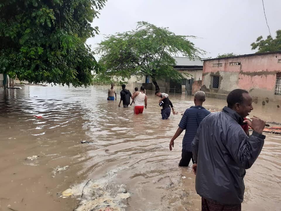
Somalia has experienced a repeated flood of most of its riparian areas every year causing displacement and loss of life. Most recently, heavy rains occurred early this month, left severe flash floods in the capital, Mogadishu and Jowhar. More than 10 people including children were killed while hundreds were displaced and crops destroyed near Jowhar.
While continuously exploring new ways to optimize the use of technology, collaboration will be the driving force behind innovation for the relief and emergency response efforts of FAO and its partners, FAO said. humanitarian in Somalia.
"This funding will support a partnership with Airbus, a pioneer private company in the aerospace sector, with exclusive commercial access to the Disaster Monitoring Constellation, Pléiades, SPOT, TerraSAR-X and TanDEM-X satellites,” FAO said.
The new project will support key data collection activities for FAO’s Somalia Water and Land Information Management (SWALIM) using remote sensing and image analysis for powerful flood monitoring actions and events. In particular, the satellite images obtained by Airbus will be used to assess the condition of the banks of the Shabelle and Juba rivers currently considered high risk, providing up-to-date and important information for standardization and respond to floods.
According to United Nations estimates, recent torrential rains across Somalia have affected an estimated 166,000 people. At least 150,000 people are currently threatened by impending flooding. FAO said it has observed the Shabelle River’s water levels continue to rise alarmingly over the past two weeks following "unprecedented heavy rains in the upper regions of the Ethiopian highlands” that have been particularly intense in recent weeks.
"We wish to support the innovative and technological approach of the FAO in the monitoring and prevention of floods in Somalia at a critical time. We see disaster management as a key issue to preserve livelihoods and break the cycle of humanitarian crises facing the Somali people,” said Aline Kuster-Ménager, Ministry for Europe and Foreign Affairs, Ambassador of France in Somalia.
Satellites and new technologies have proven to be game-changers in emergency efforts in recent years. Remote sensing tools continue to help pave the way and open up new horizons by reaching remote or previously inaccessible rural areas, especially during the COVID-19 era.
These new tools not only inform rescue and response operations, they also aid in flood preparedness and emergency planning. In addition to mapping shore breaks, SWALIM also monitors flood potential areas along the Juba and Shabelle rivers using very high resolution satellite images; This information plays an important role in helping local governments and communities close open vulnerabilities and monitor potential new vulnerabilities.
In addition, when flooding is likely to happen, SWALIM will activate the ‘Digniin’ early warning system, which sends SMS alerts to high-risk riparian communities.
"This funding underpins an agreement between FAO and Airbus which gives the flexibility to load very high resolution images in a very short period of time. This means that we will be able to improve our efficiency in response to flood-related emergencies,” noted Ugo Leonardi, SWALIM technical advisor.

- Popular
- Rated
- Commented


04/11/2021 - 11:05:02


28/05/2024 - 15:44:10


02/12/2021 - 11:34:53


01/03/2021 - 09:00:37


Opinions


18/05/2025 - 16:26:37

15/05/2025 - 20:16:04
Politics


05/06/2025 - 13:42:50

Terror Watch

07/06/2025 - 21:36:45


Press Releases

05/06/2025 - 12:21:21


02/06/2025 - 21:29:33


With funding from France, UN's FAO eyes new technological innovations for flood response in Somalia
MOGADISHU (HORN OBSERVER) — The Food and Agriculture Organization (FAO) of the United Nations and the French Government on Tuesday announced a partnership in kind, which will allow FAO and other organizations to strategically focus their flood